Save this image free of charge
in 800 pixels for layout use
(right click, Save as...)
|
|
Ref : V01856
Theme :
Looking at Earth - Plains - Plateaus - Valleys (487 images)
Title : Patagonia, Argentina
Caption :
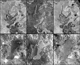
In addition to an elevation model of most of Earth's landmass, the Shuttle Radar Topography Mission will produce C-band radar imagery of the same area. This imagery is essentially a 10-day snapshot view of the Earth, as observed with 5.8 centimeter wavelength radar signals that were transmitted from the Shuttle, reflected by the Earth, and then recorded on the Shuttle. This six-image mosaic shows two examples of SRTM radar images (center) with comparisons to images acquired by the Landsat 7 satellite in the visible wavelengths (left) and an infrared wavelength (right). Both sets of images show lava flows in northern Patagonia, Argentina. In each case, the lava flows are relatively young compared to the surrounding rock formations.In visible light (left) image brightness corresponds to mineral chemistry and -- as expected -- both lava flows appear dark. Generally, the upper flow sits atop much lighter bedrock, providing good contrast and making the edges of the flow distinct. However, the lower flow borders some rocks that are similarly dark, and the flow boundaries are somewhat obscured. Meanwhile, in the radar images (center), image brightness corresponds to surface roughness (and topographic orientation) and substantial differences between the flows are visible. Much of the top flow appears dark, meaning it is fairly smooth. Consequently, it forms little or no contrast with the smooth and dark surrounding bedrock and thus virtually vanishes from view. However, the lower flow appears rough and bright and mostly forms good contrast with adjacent bedrock such that the flow is locally more distinct here than in the visible Landsat view. For further comparison, infrared Landsat images (right) again show image brightnesses related to mineral chemistry, but the lava flows appear lighter than in the visible wavelengths. Consequently, the lower lava flow becomes fairly obscure among the various surrounding rocks, just as the upper flow did in the radar image. The various differences among all of these images illustrate the importance of illumination wavelength in image interpretation. The radar images shown here were acquired by the Shuttle Radar Topography Mission (SRTM) aboard the Space Shuttle Endeavour, launched on February 11, 2000. SRTM used the same radar instrument that comprised the Spaceborne Imaging Radar-C/X-Band Synthetic Aperture Radar (SIR-C/X-SAR) that flew twice on the Space Shuttle Endeavour in 1994. SRTM was designed to collect three-dimensional measurements of the Earth's surface. To collect the 3-D data, engineers added a 60-meter-long (200-foot) mast, installed additional C-band and X-band antennas, and improved tracking and navigation devices. The mission is a cooperative project between the National Aeronautics and Space Administration (NASA), the National Imagery and Mapping Agency (NIMA) of the U.S. Department of Defense (DoD), and the German and Italian space agencies. It is managed by NASA's Jet Propulsion Laboratory, Pasadena, CA, for NASA's Earth Science Enterprise, Washington, DC.Size (top set): 21.3 kilometers (13.2 miles) x 25.0 kilometers (15.5 miles) Size (bottom set): 44.1 kilometers (27.3 miles) x 56.0 kilometers (34.7 miles) Location: 41.5 deg. South lat., 69 deg. West lon.Orientation: North toward upper left (top set), North toward upper right (bottom set) Image Data: Landsat bands 1,2,3 (left); SRTM Radar (middle); Landsat band 7 (right) Date Acquired: February 19, 2000 (SRTM), January 22, 2000 (Landsat)
|
|

